A Digital Elevation Model (DEM) is an image (raster) in which the pixel values represent the elevations above sea level of the ground. If there are buildings, trees or other features on the ground in the area of a given DEM, those features are assumed to not be included in the elevation values included in the DEM but would be included in a Digital Surface Model (DSM). The term Digital Terrain Model (DTM) is used interchangeably with DEM.
To take an image that is already in a known coordinate system, and provide the information necessary for software to understand which coordinate system it is in.
Geocode:
Same as georeference.
Georectify:
To take an image that has not been adjusted to be in a known coordinate system, and put it into a known coordinate system. Usually this means taking an image that is in its original geometry, and putting it into a map projection. There are different ways to do this. Perhaps the most common way is to identify a set of points in the image for which the latitude and longitude or map coordinates are known, and use them to warp the image into a map projection.
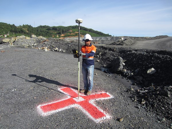
Ground Control Points (GCPs) are defined as points on the surface of the earth of a known location used to geo-reference data. As the GCPs are in a known, fixed location, they can be used as an additional reference point for the data, improving upon the level of accuracy that you would receive if you were relying on geo-tagging of photos alone.
Normally, a target is used under the point and take the shape of an ‘X’, which can be identified easily from aerial photography taken by a uas or full size aircraft.
Ground Control Points can be established permanently on sites where repeated surveys are anticipated and need not be placed each time.
GCP Establishment
A surveyor establishing a ground control point at a mining site.
The discipline of gathering, storing, processing, and delivering Geographic information or Spatial reference information.
It consists of products, services and tools involved in the collection, integration and management of geographic data.
A geographic information system (GIS) lets us visualize, question, analyze, and interpret data to understand relationships, patterns, and trends.
GIS benefits organizations of all sizes and in almost every industry. (more)
LIDAR is a surveying method that measures distance to a target by illuminating that target with a laser light. The name lidar, sometimes considered an acronym of Light Detection And Ranging, (sometimes Light Imaging, Detection, And Ranging), was originally a portmanteau of light and radar. Lidar is popularly used to make high-resolution maps, with applications in geodesy, geomatics, archaeology, ecology, geology, geomorphology, seismology, forestry, and contstruction. Lidar sometimes is called laser scanning and 3D scanning, with terrestrial, airborne, and mobile applications. (more)
An orthoimage, orthophotograph or orthomosaic is an aerial photograph geometrically corrected “orthorectified” such that the scale is uniform. This removes the distortion found in perspective photographs.
To take an image in its original geometry and very accurately adjust it so that it is in a known coordinate system, with distortions due to topographic variation corrected, has uniform scale throughout the image, and appears as though each pixel were acquired from directly overhead.
Photogrammetry has been defined by the American Society for Photogrammetry and Remote Sensing (ASPRS) as the art, science, and technology of obtaining reliable information about physical objects and the environment through processes of recording, measuring and interpreting photographic images and patterns of recorded radiant electromagnetic energy and other phenomena.
In simple terms, Photogrammetry is the science of making measurements from photographs, especially for recovering the exact positions of points on the surface of the Earth. (more)
Root Mean Squared Error (RMSE) is a measure of the difference between two sets of values in Structure from Motion. It is commonly used to evaluate the accuracy of 3D reconstruction of a scene from multiple 2D images by comparing the reconstructed 3D points with accurate ground check points or monuments. RMSE represents the average distance between the reconstructed points and the ground check points, with lower values indicating more accurate reconstructions.
Structure from motion (SFM) as applied to using unmanned aerial systems (UAS) for topography refers to the process of using a series of 2D images captured by a camera mounted on a UAS to reconstruct a 3D model of the terrain. This technique involves analyzing the motion of the UAS and camera across multiple frames to infer the 3D structure of the terrain, including its elevation, slope, and surface features. The resulting 3D model can be used for a variety of applications such as mapping, surveying, and monitoring changes in the terrain over time.